Showing posts with label cliffs. Show all posts

Saturday, 6 July 2024

East cliff, Bridport


The Jurassic Coast is a World Heritage Site that stretches 96 miles (154 km) along the south coast of England from Exmouth in East Devon to Studland Bay in Dorset. The cliffs along the coast date from the Triassic, Jurassic and Cretaceous periods of geological history. Their rich fossil beds were one of the places where palaeontology emerged as a discipline that explained the earth's past.

The cliffs of the coast vary considerably in age and stability. East Cliff, near the small harbour town of Bridport, Dorset, is quite unstable and visitors are requested by signs to keep away from the base of the cliffs. It is a popular place for dog walkers and fossil hunters, not all of whom comply with the warnings.

photo © T. Boughen     Camera: Nikon Z 5

Saturday, 27 May 2023

Guillemots at Stackpole Head, Pembrokeshire


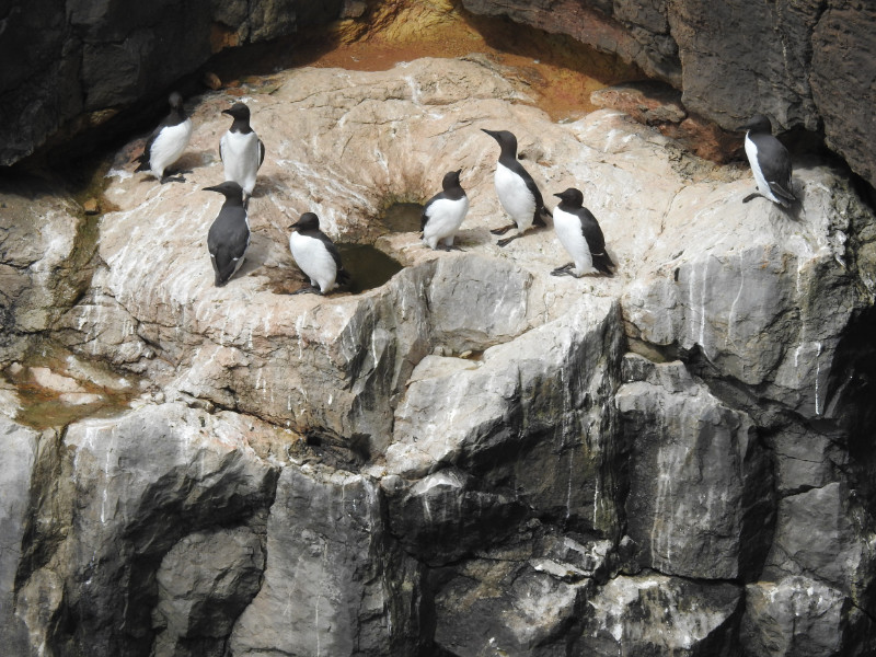
At the time of our visit to Stackpole Head in early May the guillemots were gathering ready for the breeding season. This species does not build a nest but lays a single pyriform (pear shaped) egg directly onto the rock ledge. The advantage of an unusually pointed egg is that, if it rolls, it does so in a tight circle and is therefore less likely to fall off the ledge.

In the southern UK the first eggs are laid in mid-May. In the north early June is more typical. Guillemots are communal nesters (and feeders, as the second photograph shows.

Incidentally, the location of the guillemots in the first photograph can just be discerned on the lower right hand edge of the top photograph of the previous post.

photo 1 © T. Boughen     Camera: Nikon P900

photo 2 © T. Boughen     Camera: Nikon Z 5

Tuesday, 23 May 2023

Pembrokeshire sea cliffs


The Pembrokeshire Coast National Park seeks to preserve and make available the beauty and interest of the coast of this part of Britain. It features sea cliffs, caves, natural arches, bays, estuaries and islands, and the whole of the National Park has a publicly accessible footpath that hugs the coastline. The photograph at the top of the page shows the view northwards from above Barafundle Bay, near Stackpole Quay. An inshore fishing boat seemed to be checking whatever was fastened to the buoys.


 The photograph immediately above shows the same boat from a different point on the headland with sea caves in the cliffs beyond.

photos © T. Boughen     Camera: Nikon Z 5

Sunday, 9 April 2023

Climbers, Llangatwg disused quarries

Click photo to enlarge

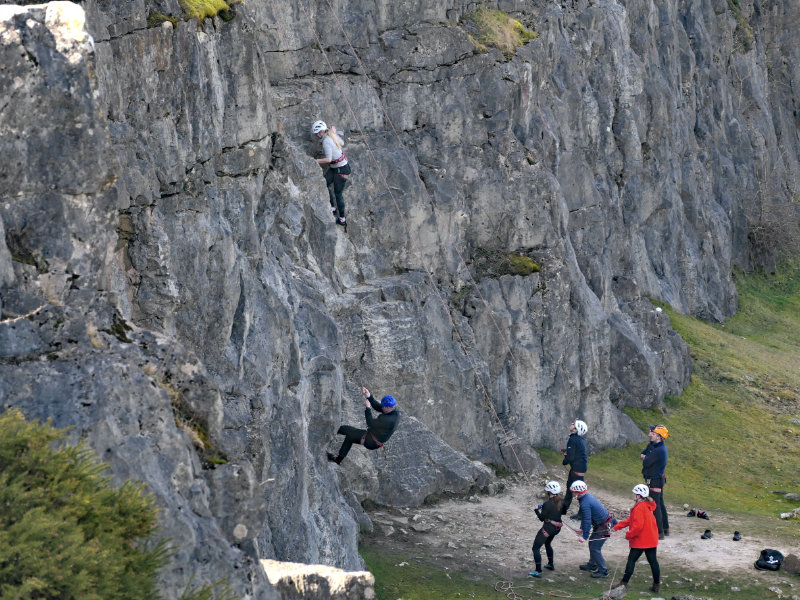
A recent walk with our children and grandchildren found us at the disused quarries at Llangatwg above Crickhowell and the Usk Valley of Wales. The area, called Llangattock in English, was extensively quarried in the nineteenth century to provide limestone for iron-making, for "sweetening" the land, and for making whitewash, among other uses. A series of tramways were used to deliver the limestone to the canal and other locations.

Today much of the cliffs, spoil heaps and the higher plateau is an open-access area and nature reserve. We saw plenty of ravens, common buzzards, red kites,wheatears and a noisy pair of peregrine falcons. We also came across climbers making use of the worked cliff faces.

photos © T. Boughen     Camera: Lumix FZ1000 2

Monday, 6 June 2022

Cliffs, beach and boats at Beer, Devon


The Jurassic Coast is a World Heritage Site that stretches 96 miles from Exmouth, Devon to Studland Bay, Dorset. It is renowned for its cliff exposures of almost continuous geology from the Triassic, Jurassic and Cretaceous periods, and particularly the range of fossils associated with those eras. Some of the earliest palaeontology took place on this coast. The cliffs at Beer feature chalk of the Cretaceous period.

The commercial fishing at Beer seems to feature a wide range of English Channel fish and shellfish.


 photo © T. Boughen     Camera: Lumix FZ1000 2

Saturday, 4 June 2022

Beach at Beer, Devon


The oddly named coastal village of beer in Devon gets its name from the Old English bearu meaning a woodland grove. The present village is wooded and has a stream flowing through it down to the sea. Today the beach reflects the settlement's two main sources of income - fishing and tourism. In the past Beer was associated with smuggling that made use of the cove and the caves in the cliffs.

photo © T. Boughen     Camera: Lumix FZ1000 2

Tuesday, 31 May 2022

Beach at Sidmouth, Devon


The shingle beach at Sidmouth, Devon, is constrained by the presence of cliffs to the east and west. Like many towns along this coast its name derives from  its geographical location where a river flows into the sea. In this case the town is at the the mouth of the River Sid. The settlement, again like many of its neighbours, was principally a fishing village but today its prosperity derives from tourism. The attractive sea front with thatched houses on the cliffs now draws visitors who want to experience the beach and the water sports that are available.

photo © T. Boughen     Camera: Lumix FZ1000 2

Thursday, 12 August 2021

The Gloucester Hole near Chepstow


When you stand on the Chepstow (Wales) bank of the River Wye and look across at the Gloucestershire (England) bank, you notice, in the limestone cliffs, an unnatural looking square hole with sides of about five and a half feet. It is accessible only from a boat at high tide. This hole leads into a large chamber whose origin isn't entirely clear. It is said to have been an enlarged natural feature that may have been a store for tea or explosives, though a more likely purpose was as a transhipment site for goods brought by sea-going ships that would be put into smaller boats for carriage up the Wye to Monmouth, Hereford and other destinations.

The painted Union flag nearby originated in connection with the Silver Jubilee of King George V in 1935. It has been repainted periodically.

photo © T. Boughen     Camera: Nikon D5300